Acoustic Zoom promises to provide high-resolution images of offshore oil and gas reserves
News, Ocean, Seismic Surveys Add commentsA small item in the Marine Technology Reporter just clued me in to what looks to be an interesting new line of acoustic imaging products that could have potential to augment, or perhaps reduce the need for, repeated seismic surveys of active oil and gas fields. PanGeo Subsea has announced new financing to develop their Acoustic Zoom, which they compare to a “deep earth telescope” capable of providing detailed imagery of subsea geology down to 6000m below the sea bed. Current information does not clarify any details about the products’ acoustic output.
Most companies now utilize repeated seismic surveys in order to track the depletion of offshore oil fields; doing repeated 3D seismic surveys over time is termed “4D” surveying. According to a recent PanGeo press release and backgrounder, one of the major limitations of current marine 4D surveys is that the resolution at reservoir depths is often too coarse to be able to focus the seismic attributes to a specific compartment or feature of the reservoir. Their Acoustic Zoom is pitched as a novel high resolution method which uses steered beams on reception and on transmission to produce images with higher definition than can be attained with conventional seismic techniques. They project that it will “reduce the cost, scheduling and logistics involved with 4D seismic imaging, including reductions in the amount of equipment, data acquisition time, as well as the time to compute and interpret seismic results. We expect our technology to become an important tool for permanent reservoir monitoring applications.” To , read more about the Acoustic Zoom, see the these two press releases, announcing private funding received in July, and Canadian government funds received in February.

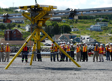
PanGeo Acoustic Corer: the arms turn to image a full circle below
There is no information on the company’s website about the source levels or frequencies of the acoustic pulses used by any of their innovative systems. In addition to the Acoustic Zoom, which is still under development, PanGeo has previously brought to market two related products, the Acoustic Corer and the Sub-Bottom Imager. The Acoustic Corer provides high-resolution images that can be manipulated in great detail; each scan covers an area 14m in diameter and 30-80m deep. See this page for three videos of the Acoustic Corer and its data. The Sub-Bottom Imager is an ROV that moves along the seabottom, making images 5m wide and 5m deep. Both of these products are more oriented toward pre-construction surveys to help avoid surprises as infrastructure is being placed on or into the seafloor.
