New NOAA maps offer compelling picture of ocean noise
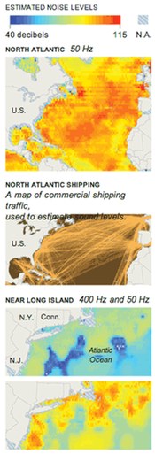
Bioacoustics, Ocean, Ocean energy, Science, Shipping, Sonar Add comments In December, NOAA announced the release of the first large-scale ocean noise maps, which have been in development for the past two years. The Underwater Sound Field Mapping Working Group modeled many sources of sound occurring within 200 miles of the US coast (including ships, seismic surveys, sonar, pile driving, and oil platform decommissioning), as well as modeling shipping noise in full ocean basins (including the Atlantic, pictured at left). Data is compiled in several depths and frequency ranges, to account for the full spectrum of various species’ habitat usage and hearing/vocalization ranges.
Dr. Leila Hatch, co-chair of the Working Group, said too many areas of the ocean surface (where sea mammals and whales spend most of their time) are orange in coloration, denoting high average levels. “It’s like downtown Manhattan during the day, only not taking into account the ambulances and the sirens,” she said. “I’d be happier saying it was like a national park.”
Michael Jasny, a senior policy analyst with the Natural Resources Defense Council, which has sued the Navy to reduce sounds that can harm marine mammals, praised the maps as “magnificent” and their depictions of sound pollution as “incredibly disturbing.”
“We’ve been blind to it,” Mr. Jasny said in an interview. “The maps are enabling scientists, regulators and the public to visualize the problem. Once you see the pictures, the serious risk that ocean noise poses to the very fabric of marine life becomes impossible to ignore.”
NOAA has set up a website where this ongoing work will be made available. In addition, an 85-page report brings together presentations and recommendations from a two-day symposium held last May, at which the Working Group presented their draft results to a couple hundred other experts from agencies, the Navy, oil and gas industry, academia, and nonprofit groups (I was fortunate to be invited to participate in that meeting).
Equally exciting is a companion project by a Cetacean Density and Distribution Mapping Working Group, also introduced at the May symposium, that is working to compile all known studies of whale and dolphin population distribution. Tens of thousands of cetacean observations are being compiled into month-by-month distribution charts and maps for various ocean regions around the US. In addition, seasonally biologically important areas (e.g., for breeding, feeding, or mating) are being compiled as part of this work.
The two mapping projects will provide a robust new foundation for assessing the impacts of noise sources, and hopefully to encourage efforts to reduce human noise, especially in biologically important areas. A New York Times article introducing the noise mapping project includes encouraging words from Michael Bahtiarian, an adviser to the United States delegation to the International Maritime Organization, which is looking at ways to reduce ship noise and vibrations. “Right now we’re talking about nonbinding guidelines,” he said “At a minimum, the goal is to stop the increases.” See earlier AEInews coverage of the IMO efforts from 2008, 2009, and 2012.
SEE ALSO: Detailed ocean noise maps take this approach further in Puget Sound, BC coastal waters
