Powerful mapping sonar likely triggered Madagascar mass stranding
Effects of Noise on Wildlife, Ocean, Sonar Add commentsAEI lay summary of:
Southall, B.L., Rowles, T., Gulland, F., Baird, R. W., and Jepson, P.D. 2013. Final report of the Independent Scientific Review Panel investigating potential contributing factors to a 2008 mass stranding of melon-headed whales (Peponocephala electra) in Antsohihy, Madagascar.
Download full report or executive summary.
See IWC website for report and all supporting materials
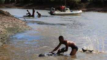 For the first time, a mass stranding appears to have been triggered by a relatively high-frequency mapping sonar; most previous strandings (though rare) have been associated with mid-frequency military sonars. An international, independent scientific review panel (ISRP) of five well-known marine mammal researchers has concluded that a 2008 stranding event on the northwest coast of Madagascar was likely precipitated by an avoidance response to a multi-beam echo-sounder system (MBES) being used to map the seafloor.
Over a hundred melon-headed whales, deep-water foragers who normally live far offshore, became trapped in a shallow estuary one day after the MBES was active 65km off the coast; locals and international marine conservation organizations collaborated for three weeks to save floundering whales, with at least 75 confirmed dead. The ISRP investigated all known possible causes for such events, and concluded that the most likely trigger was that the whales were moving away from the sonar, and became trapped in the unfamiliar surroundings of the narrow La Loza Bay estuary. There, they found it hard to orient and navigate in the shallow, murky water; lack of food sources, stress/fatigue, and an accumulation of small injuries led to eventual death for most.
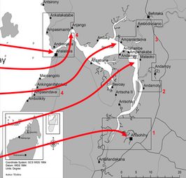 Acoustic modeling suggests that the whales would have been able to hear the MBES signals for at least 30km from the survey vessel, to near the island seen on the map to the right, 25km offshore, at which point they apparently continued moving toward shore until straying into the stranding zone. Why the animals continued moving inshore after the sonar was no longer audible is unclear. This is a species that normally lives only in deep waters; once the whales moved past the cliff near the survey area and into shallow shelf waters, they may have been quite confused, and further behavioral anomalies (including ending up in the estuary) may be unrelated to the survey sounds.
UPDATE, 10/10/13: This WaPo article includes some skeptical responses, centering on the uncertainties about other factors (before and/or after the MBES sound exposure) that may have contributed to the stranding, and concerns that the strong language of this report could lead to an over-reaction among regulators. A spokesman for Exxon-Mobil, which helped fund the study and the initial stranding responses, said, “our contract vessel happened to be there in that time frame, but there are so many uncertainties in the area that we’re not sure it’s us.” Still, the company has changed its practices to avoid use of MBES near sharp cliff faces, since the panel speculated that echoes off the cliff may have confused the whales, sending them further inshore.
The ISRP report concludes that “this clearly appears to be an atypical event,” yet also stresses that the MBES system may pose previously unrecognized risks:
It is important to note that these systems, while regularly used throughout the world in hydrographic surveys, are fundamentally different than most other high-frequency mapping or navigational systems (ed. note: or fish-finding sonars). They have relatively lower source frequencies (12 kHz is within the range of likely best hearing sensitivity for all marine mammals), very high output power, and complex configuration of many overlapping beams comprising a wide swath. Intermittent, repeated sounds of this nature could present a salient and potential aversive stimulus.
Click on through for more details on the stranding, the ISRP report, and maps.
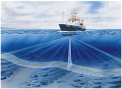 Multibeam echosounder systems operate at very high-power, with source levels as loud (220-240dB) as the Naval sonars that have been the trigger for several high-profile strandings over the past fifteen years. Its 12kHz signal is higher frequency than Naval mid-frequency active sonars and in the range of optimal hearing for many toothed whales (dolphins and fish-eating, echolocating whales such as orcas and sperm whales, as well as the deep-diving beaked and melon-headed whales).
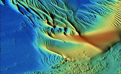 MBES mapping sonars are widely used for academic and government agency research, as well as for seafloor mapping by the oil and gas industry as they choose and develop sites for seafloor development and pipeline routes. The technology was developed in the 1970s, and by 1990 had evolved to allow high-resolution imagery, including use in shipwreck excavation. Modern systems include 50 or more individual beams; this complexity of sound sources is part of what the ISRP researchers suggest could be problematic:
Given the observations here, with the caveats given, there should be increasing realization that powerful active sonar systems other those previously scrutinized (namely military tactical mid-frequency sonars) may have detrimental effects on marine mammals. This is particularly true of systems with output frequencies in the 10-50 kHz range with output levels exceeding 230 dB and complex multi-beam arrays of sources. Such sources may in fact be more relatively audible and potential disturbing to some marine mammals than lower frequency sources previously considered, particularly for odontocete cetaceans that are acoustically most sensitive in these frequency regions. This event suggests that there may be a risk of causing strong behavioral reactions and even harm from such systems. While this risk may arguably be very low given the extensive use of such MBES systems historically and the lack of direct evidence of such responses previously, environmental planning and assessment of such operations should account for this potential and consider local species and spatial relationships of operations relative to local topographical features in planning operations. Furthermore, melon-headed whales may be among the more reactive and potentially vulnerable marine mammal species to impacts from powerful acoustic systems based on the combined observations of their movements to date (see: Southall et al., 2006; Brownell et al., 2006; 2009)
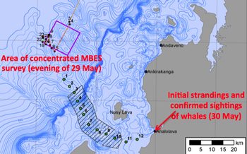 The last bit from the report that I’d like to share here is the sound propagation modeling undertaken by the ISRP. Simple modeling confirmed that sound of 120dB or more extended in a wide band around the ship’s track, almost to the bright blue sharp slope (underwater cliff) seen between the survey area and shoreline on the map to the left; many species of deep-diving whales have been shown to be sensitive to sounds down to 120dB, which is 50-60dB louder than melon-headed whales’ hearing threshold at 12Hz. Thus, the ISRP team modeled sound propagation from the ship’s track, toward the stranding site. It appears likely that the MBES sounds were clearly audible at modeling site 7, and faded to inaudibility between sites 8 and 9 (directly between the two islands shown on the map). The presumed avoidance response occurred as the ship worked on May 29 at the offshore area noted; whales apparently remained nearshore during the next day, and began stranding at some point on the 30th, making their way all the way to the end of the estuary by the end of the 31st. Rescue efforts continued until June 23, with many whales being eased off the mudbanks along the shores; it’s not clear whether any are known to have swum back to sea. Most of the dead whales were quickly scavenged by locals for food.

October 9th, 2013 at 10:16 pm
Models predict, not confirm. Inadequate models will predict incorrectly.